
Independence and Partition
Before India gained its independence, the area that is now Bangladesh was part of British-controlled India.
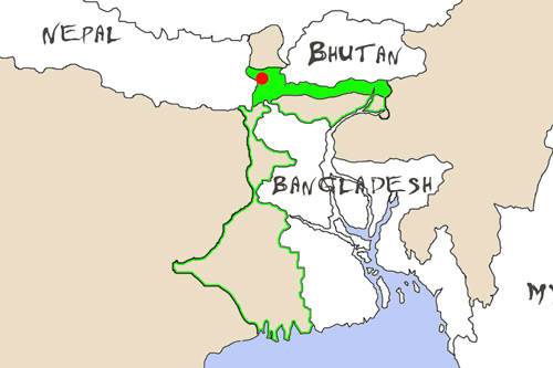
Since independence and the partition of India into two countries (India and Pakistan) in 1947, the north east of India has only been connected to the rest of the country by a narrow ribbon of land that runs between Bangladesh and Nepal.
A Side Note About Bangladesh
As a side note, in 1947 Bangladesh became a province of Pakistan and was named East Bengal. It was later renamed East Pakistan and then, following a dispute with West Pakistan in 1971, it broke free and became Bangladesh.
I haven’t indicated where Pakistan is on the map, but if you are not sure, it is way over to the west of India. In other words, before Bangladesh broke free, Pakistan was a country in two parts – with over one thousand one hundred miles (1,800km) between the two parts. Is it any wonder that Bangladesh became an independent country?
West Bengal
Whatever its history, the fact is that the Indian state of West Bengal covers both a large lowland area around the state capital Calcutta and a highland area in the north – with the two connected by a narrow ribbon of land around Siliguri.
Darjeeling
The road from Siliguri climbs steadily to Kurseong, which is about halfway to Darjeeling. From then onwards the road continues its upward climb but it is in a noticeably worse condition, full of large potholes.
Everything about Siliguri reminds you that you are in India. In contrast to that, walking around Darjeeling and other towns in the Darjeeling region we get the impression that we are not in India. The people are different – mostly of Nepali descent, with a sprinkling of Tibetans.
Compared to other places we have visited in India, the people seem more ascetic, a little more stoic, less exuberant and, except for the monks from the monasteries, wear much less colorful everyday dress.
Perhaps we shouldn’t be surprised: The people of Darjeeling and the the region known as the Dooars that runs east from Darjeeling, consider themselves a separate linguistic and ethnic group from the lowland area.
Thus the majority language around Darjeeling is Nepali and the predominant religion is Buddhism.
We are told that Nepali is similar to Hindu, and that the two languages are mutually intelligible to some extent.
We are also told that Nepali is quite different from Bengali, which is the official first language of West Bengal – and therein lies the problem.
The Official Languages Of West Bengal
Nepali is an official second language of West Bengal, but it runs a poor second to Bengali. As it stands at the moment, a Bengali speaker from Calcutta could enter university or take a government job being able to speak only Bengali, but a Nepali speaker would have to show proficiency in Bengali.
And there are only two universities in India running courses where the language of tuition is Nepali.
Statehood
The people of Darjeeling and the Dooars believe they would do a lot better economically if they had control over their own budget and their own political decision-making.
As a result, they want separate statehood.

They have been asking for this since 1907 when they made their first representation to the British, who controlled India at the time. They have continued to make representations and demands for statehood since India gained its independence in 1947.
Signs and Signboards
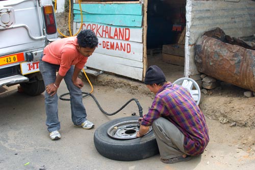
There are signs for Gorkhaland – the name of the state that the people of the area are asking for – everywhere. Almost every road sign and shop and hotel signboard has the name Gorkhaland painted or tacked on to it somewhere.
On the way to Kurseong our shared taxi had a flat tire. The driver stopped at a village and the mechanic repaired the leak and pumped up the tire. The Gorkhaland sign on the shed is typical of signs all over the region. [The small amount of tread left on the tire may be typical also.]

Gorkhaland
The main group of Nepalis in the Darjeeling region are Gorkhas. According to some sources they invaded from Nepal in the 1700s. According to other sources they came when the British were granted part (and then subsequently annexed a further part) of the area from Sikkim [Sikkim is the state immediately to the North of Darjeeling].
To the British they are known as Gurkhas. There is a British Army Brigade of Gurkhas today and Gurkhas have been known for their bravery since the days of the British Indian Army during the pre-independence days of India.
That is the background.
Meetings, Meetings, Meetings
Yet another meeting to discuss the Gorkhas demand for statehoold was held in Delhi on March 18th.
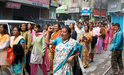
On the day of the meeting we saw a demonstration in Darjeeling. The demonstrators passed by in groups – well dressed women holding parasols against the sun, children in their school uniforms.
What struck me was the number of saris and shalwar kameez. Where were these fine outfits on a normal day? Were they middle class women who didn’t normally come into town? Had the demonstrators saved their finest outfits for this special occasion? It seemed so.

Kurseong
We also saw a demonstration in Kurseong – a hill town about 15 miles (25km) from Darjeeling – which we were visiting to see a tea factory in operation.
Again the demonstrators were dressed very well, as though for a special occasion, and were very dignified.

